Wednesday, May 9, 2012

The Potential Impacts of Global Climate Change on Duluth, MN (Final Blog)


The Potential Impacts of Global Climate Change on Duluth, MN
Final Blog
While Duluth's mid-continental location spares he city from areas of potentially significant impacts of climate change such as small islands and coastal regions, Duluth is not immune to climate change. Not surprisingly, global climate change will affect all areas of the planet not matter their proximity to oceans, the equator, or anywhere else. The question is, how much of the looming giant that is global climate change will fall upon Duluth? 


  • Intergovernmental Panel on Climate Change (IPCC) projections


Global warming in Duluth could be damaging.  A decrease in lake level orgreater lake level flucuations
 during summer months could prevent harbor use.  Conversely, this could decrease the length of harbor
 freeze-over and create a longer shipping seasing, thereby increasing commerce potential.


The IPCC is confident that climate change will certainly occur in Duluth.  Their data and analysis indicates a possible temperature change of 1-3 degrees C  (1.8-5.4 degrees F) from 2010-2039 in North America, which is to say even in the low end of the scenario, Duluth will get warmer.  So much for "the air-conditioned city.  But without getting ahead of ourselves, it must be noted that predictions call for warmer winters in higher latitudes and warmer summers is lower latitudes; of course, a mildening of Duluth's bitter winters is something that no resident wouldn't welcome with open arms.  However, looking further into the future the outlook is much more dire.  Temperature increases in Duluth's region for the years 2090-2099 is predicted to swell to 4-4.5 degrees C (7.2-8.1 degrees F).  An increase this significant will no doubt bring summer temps typical of a continental climate as soon as the end of the century. 

Precipitation is another factor which is predicted to change by IPCC research.  Much like the temperature change predictions, there is no place in the IPCC to look up exact precipitation details for Duluth, however, precipitation change can be inferred from other statements.  First, the IPCC predicts an increase in precipitation in all of North America but the southwest United States.  Furthermore, Canada is expected to see annual mean precipitation increases of 20%, and a 30% jump in the winter mean.  The IPCC also states the is is 'very likely' that precipitation will increase in higher latitudes.  Applying these statements leads to the conclusion that precipitation is predicted to increase because of Duluth's moderately high latitude and because of its proximity to Canada, Duluth could experience a rise in annual mean precipitation of as much as 20%.  Following along with the Canada statement, Duluth could expect as much as 30% more snow annually, a prediction that seriously affect the city which already receives more than its share of snowfall.

According to the IPCC's conclusions, Duluth's climate is predicted to become warmer and wetter.
While the short-sighted might agree that this shift in climate make their lawns greener and nothing more miss the damage that climate change could bring to the Lake Superior region.  in addition to the IPCC's predictions, the University of Minnesota SeaGrant Program predicts:  dryer summers with a reduction in soil moisture content, warmer nights, increased frequency and intensity of weather events, increased variability of climate with more instances of extremes, a lowered lake level due to increased evaporation, longer growing seasons, and impacts to species in all ecosystems.  Needless to say, 'warmer and wetter' is not the whole story.


  • Extreme event projections

This diagram shows the relationships of extreme temperature to increased in variance and mean as well as
both combined.  Note that an increase in mean and variance yields will shift a normal temperature distibution
 towards a significant potential for very hot and record temperatures


Extreme events, note unlike temperatures and precipatiaon are expected to increase in Duluth.  IPCC scientists are certain that the entire globe can expect more frequent and intense daily warm temperature extremes alongside a decrease in   Duluth can also expect an increase in heat waves or other extended warm periods, something not often experienced in the lakeside city.  While the frequency of mid-latitude cyclone is predicted to increase, there is an expected 'poleward shift' of these cyclones which could bring increased storm activity to Duluth.  Also, despite the potentially wetter weather, Duluth falls within central North America, a region where the IPCC believes the frequency of droughts will increase.  On top of all this, changes in precipitation increase flood risk, putting a significant portion of the city at risk by a potential flooding of the St. Louis River. 


Wind speeds over Lake Superior have increased 5% per decade since 1985.  This could lead to more
 frequent and larger storm surge-like waves which could damage harbor structures.  Scientists also believe these
increased winds increas currents which disrupt the lake's food web.


According to UMN's SeaGrant, consensus among some climatologists indicated that the increase on extreme events in the Lake Superior region will create dramatically different climate than that which exist today.  They predict a normal day will feature widely variable high and low temperatures that push into the extremes, and the area will be increasingly plagued by opposing periods of drought and excess precipitation. 

  
  • Local impacts of climate change
The most basic impact to consider for Duluth is the effect of increasing temperatures on energy resources. Incresing temperatures would likely affect the use of energy hogs such as air-conditioners. This increased demand is sure to coincide with increased energy demand throughout the world as temperatures rise.


This flow diagram traces the consequences of a reduction of Great Lakes water levels.  Of these, Duluth
would certainly suffer from decreased transportation and tourism.  While there are no fisheries in Duluth, the
impact to species and habitat would surely decrease the natural beauty of the area.

A more direct and major potential consequence is the reduction of water levels in Great Lakes/ Lake Superior, which could seriously harm Duluth and northern Minnesota's economy.  Sea-faring vessels come from all over the world to load up on taconite pellets (refined iron ore) mined from Minnesota's Mesabi Iron Range.  If these ships cannot reach the port's loading infrastructure the important taconite industry would be instantly crippled.  Duluth's economy is also centered upon tourism which is restricted mainly to harbor activities and outdoor activities.  A closing of the harbor and/or reduction in wildlife would also hurt the important local service-based economic sector.

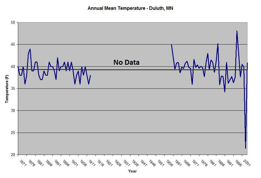
Global climate change threatens the environment in a major way besides a potential reduction of the Great Lakes' volume.  A rise in surface temperatures on  Lake Superior has been observed since 1980, and with the prospect of increase future warming this trend is likely to increase, possibly at a higher rate of change.  Over the last three decades, the surface temperature of the lake has increased 2 degrees F ever year, a rate of increase twice that which was recorded on nearby land.  This two-pronged effect of decreased water levels and increased surface temperatures could severely disrupt and decrease the rich biodiversity of the area.  Because of this, the non-humans of the Duluth area are the most likely to take the brunt of potentially anthropogenic climate change.  Interstingly, for reasons attributed to global climate change, many birds appear to have extended their northern migration into Duluth, reaching a record of 74 birds species present during a 2000 count.  This largely anecdotal evidence serves to illustrate how the many varied inputs of climate change can create many different outcomes.  It also conveys the way which global ecosystem stresses will cause many various patterns of migration, shrinking and expansion of habitats, as well as increased isolation of species.


During the summer, Northern Minnesota is home to a large population of Bald Eagles.  A minor change to
 the trophic system by alterations in lake volume and temperature could potentially damage the eagle's food sources.
 A decline in Bald Eagle nesting near Duluth would also hurt tourism.

  • Duluth's climate change mitigation measures

In response to emerging research regarding the reality of global climate change, Duluth became a part of of the "Cities for Climate Protection Campaign" sponsored by the International Council for Local Environmental Issues (ICLEI) in 2001.  By passing a resolution to join this project, the city will work towards the goal of a 20% reduction of carbon emissions and other pollutants by 2020.  Whether or not the city will attain this goal remains to be seen.  Towards this end however, the city completes greenhouse gas emission assessments to target areas of concern, establishes a structured set of emission reduction targets, and creates a sound strategy to meet these targets.  In practice, moves to meet these targets involve many small steps such as a switch to LED streetlights.


Sources:

"Contribution of Working Group II to the Fourth Assessment Report of the Intergovernmental Panel on Climate Change, 2007", http://www.ipcc.ch/publications_and_data/ar4/wg2/en/contents.html

Fourth Assessment Report of the Intergovernmental Panel on Climate Change - Sythesis Report- Summary for Policymakers, 2007, http://www.ipcc.ch/pdf/assessmentreport/ar4/syr/ar4_syr_spm.pdf

"Global Warming, What is Duluth Doing About It?",  http://www.doitgreen.org/article/gw/duluth.

"Managing the Risks of Extreme Events and Disasters to Advance Climate Change Adaptation - Summary for Policymakers", http://ipcc-wg2.gov/SREX/images/uploads/SREXSPM
brochure_FINAL.pdf

'Minnesota Climate Change Action Plan", http://www.pca.state.mn.us/index.php/component/
option,com_docman/task,doc_view/gid,9237.

Wednesday, May 2, 2012

Temporal Analysis and Meso/Micro-Scale Climate Controls - Duluth, MN (Blog 3)


Temporal Analysis and Meso/Micro-Scale Climate Inputs
Duluth, MN -- Blog 3

-----------------------------------------------------------------------------------------------


Climate Classification

Koppen- Geiger System: "Dfb," Warm Summer Humid Continental Climate, with neither a dry summer or winter or without a warmest month above 22C, but at least four months above 10C. 

(Link to view Koppen-Geiger Map: http://upload.wikimedia.org/wikipedia/commons/7/74/Koppen_World_Map.png)

Normals, Means, and Extremes from Duluth Harbor 1971-2000.  Click image to expand.


These climate graphs support the Koppen-Geiger Classification in that July and August temperatures average below 70F (this is not far below 22C, however)  and there are at least 4 months above 50F (10C), May through September.  Year-round precipitation also supports the classification.  It is important to note that Duluth's geography brings conditions outside this rigid classification.  Maritime temperate and maritime arctic are two examples.


Meso and Micro-Scale Climate Inputs


Meso-Scale:
  •  Duluth's proximity to Lake Superior is the main meso-scale factor.  A summer heat rises, cool lake air advects inland, cooling the city.  Conversely, lake-effect/enhanced snow has brought in over 25" of snow over a 24-hour period.

Micro-Scale:
  • Orographic Influence - Duluth is split between lake level and a western ridge; orographic lift is minor ( 600-800') but nonetheless impacts precipitation distibution.

Orographic influence in Duluth. Seasonal snowfall totals on Duluth's western
ridge may receive 20" or more than portions of the city at lake level.
 
 
  • Influence of Convergence  - Air is funneled through Duluth, hindered by high terrain, it experiences directional convergence.  This deflection focuses wind directly towards the harbor where contact with the land/water interface and increased friction slows its velocity.  This frictional convergence compiles air movements as faster open-water air converges with the slower moving air over land.  Increased lifting of air as a result of convergence is a snow-enhancing mechanism which helps to account for Duluth's high snowfall amounts.

Visualization of convergence at Duluth. Frictional Convergence is the left image, Directional Convergence is shown in the center. The image on the right is meant to convey a net effect.


  • Anthropogenic Factors - Minimal. Duluth is a busy port (by midwest standards) yet these diesel-burning ships would not impact the weather station much. However, placement by the lake would yield temperatures lower than those on the hill because of cooler summer and winter temperatures at lake level.


 Duluth's Historical Climate

Mean temperature graph for Duluth Harbor.  Included data encompasses the years 1871-1913 and 1960-2004.  Data could not be located for missing years. 
Total precipitation by year for Duluth Harbor.  Included data encompasses the years 1871-1913 and 1960-1993.  Data could not be located for missing years.


Obeservation of the above trendlines in order to gauge climate change in Duluth, MN reveals a disparity:
  • Temperature - The trend appears to have no slope/ no change over time.  Yet, there is an actual dip in the line, which accounts for a minute change (39.30F to 39.26F).  This neglible value (0.04F) is not evidence of apparent climate change.  However, the fluctuations of peak to trough, shown by the extreme values, seems to increase in more recent years.  This phenomenon could be a pattern of increasing occurence of extremes due to climate change or simply the result of more accurate measurements.
  • Precipitation: There is a clear negative slope, suggesting a significant temporal reduction of precipitation from 1871-1993 of ~9".  As with the temperature example, rain gaging has advanced over time, however, this graph shows an indication of climate change worthy of notice.  Although Duluth is not an agricultural center, Minnesota surely is;  a regional decline of precipitation could damage food production. 

*This exercise highlights the importance of data in climatology work.  One incomplete dataset simply does not cut it.


Sources:
Data:
Other Information:
*Some information retrieved from previous blogs.

Tuesday, April 17, 2012

Geographic Centers: Comparative Weather and Climate (Reflection 1)

Comparative Weather and Climate of Duluth, Minnesota & Vienna, Austria

Vienna in wintertime.  Like Duluth, polar airmasses bring cold winters,
however, outbreaks of arctic air do not reach Vienna or bring the
extreme chill felt in Duluth.  In January, averages temperatures in
Vienna are 20 degress warmer than in Duluth. Image retrieved from:
 2005worldtrip.com/images/aus-wintervienna320.jpg


Vienna, Austria, blogged by Claire Brewer, is related to the the location of this blog primarily through a characteristic of geography.  Just as Duluth
falls near the geographic center of the North American landmass, Vienna is located near the center of the European landmass. 
While both regions experience a humid continental climate, there are many variations between the two.


Climatograph for Vienna, Austria showing several variables.  Note the low average sunlight received (Claire's blog noted persistent cloud cover in Vienna) and flat average wind speed curve. Retrieved from climatetemp.info.

Climate characteristics of Duluth, MN.  Note incresed wind speed during all but summer months.  Retrieved from climatetemp.info. 

The graphs above provide a basis for comparison of Duluth and Vienna.  An initial similarity between the two locations is found the black curve, relative humidity ranging from ~60-80%,  which is expected in a humid continental climate regime.  Also, both cities also fall within latitudes (~30-60 deg. N/S) that experience mid-latitude cyclones (See fig. below).  However, this is where the similarities end.    

A developing mid-latitude cyclone typical for Europe.  Convergence of cold dry cP air with warmer, moist mP air over the Atlantic sets up the systems which track eastward due to jet stream flow.  The heaviest precipitation falls in the British Isles where orographic influences exist.  Yet, an absence of north/south mountain ranges creates little impedement for a mid-latitude cyclone to move towards Vienna (approximate location shown on the image as a black star). 
 Image retrieved from: www.fas.org/irp/imint/docs/rst/Sect14/AAAMBHBA.jpg


Airmasses:
The airmasses which affects Duluth and Vienna are the main cause of variation, continental polar (cP) and maritime polar (mP), respectively   The climatographs show that Vienna experiences a milder winter in comparison to Duluth likely because of the influence of mP air, which is warmer than cP air, since the ocean will retain a higher surface temperature than that of a continental landmass.  Just as summer heat is mellowed by cool wind from Lake Superior, Vienna's summers are mild as a result the cool marine influence (mP), brought in by prevailing westerly winds.


Precipitation and Severe Weather:


Surface heating in both locations leads to summer showers and thunderstorms, yet Duluth experiences a greater spike in summertime precipitation.  Considering the East-West trend of topographic features, the Swiss Alps squeeze out the moisture moving from Mediterrean, which leaves the Altlantic-based mP airmass as Vienna's source of precipitation.  Far inland, Vienna receives little of the moisture and experiences a drier summer in comparison.  In Duluth, evaporative processes over the Great Lakes combined with the northward advance of mT air from the Gulf results in moister conditions and more precipitation.  For example, in June, Vienna receives 10" whereas Duluth doubles the figure with 20".


Devastation of August 1969 tornado near Duluth.  A reported 15 people were killed.  Retrieved from: hill.areavoices.com/files/2010/09/boulderlake1-1024x715.jpg

Both locations are susceptible to tornadoes, especially Duluth which lies on the northernmost extent of North America's "Tornado Alley."  Moist Gulf air will contact the cold, dry cP airmass that affects Duluth, however, the occurrence rate is significantly lower than the annual state average of 27.  On the other hand, only 1.2 tornadoes occur per year in the greater Vienna region as cyclonic conditions are rare. 


Sources:


Airmasses Over Europe: http://meteorologytraining.tpub.com/14312/css/14312_104.htm


Minnesota Tornado History and Statistics: http://climate.umn.edu/doc/historical/tornadic.htm


Tornado Climatology of Austria: http://tordach.org/at/Tornado_climatology_of_Austria.html


Thursday, April 5, 2012

Weather and Climate Playmakers (Blog 2)

Duluth's Weather and Climate Playmakers: Air Masses, Fronts, and Unique Factors

  • Air Masses
The air mass which has the greatest effect on the weather and climate of Duluth, MN is cool, dry Contintental Polar air that is present year-round.  The much colder and very dry Continental Arctic (cA) air mass often pushes southward into Duluth during the winter, however, the mass quickly receeds due to summertime insolation of the northern latitudes.

Duluth lies well within the exent of the cP air mass which brings cool air that mollifies
the summer heat; a buldging of the the cA in the winter months brings bitter cold.

Occasionally, summer heatwaves can occur when warm Marine Tropical (mT) and Continetal Tropical (cT) airmasses push northward into the region.  A late season push of mT air has the potential for early snowstorms as was seen in 1991 (See figure below).


The Halloween Blizzard of 1991.  A warm, moist mT front swept north from the
Gulf of Mexico that pounded Duluth with 36.9" of snow.


  • Fronts and Mid-Latitude Cyclones
Although mid-latitude cyclones often mature further south, Duluth is still affected by these cyclones.  The diagram below shows Duluth in the center of the the occluded low pressure, just at the tail of the cold occlusion.


This low pressure "land-bomb" late October, 2010 was touted as stronger
than the historic storm that took the Edmund Fitzgerald.

Mid-latitude cyclone with occlusion and low pressure system near Duluth.

The "Current Fronts" map shown below indicates a cold front moving towards Duluth. With no warm front visible in its path, it is unlikelythat an occluded front will form and spawn a mid-latitude cyclone. This will likely push through bringing cooler temperatures in the next few days.
Weather Underground Front Map shows advancing cold front.
  • Unique Factors
In addition to the topographic and other factors introduced in the previous blog, there are several others worth mentioning: 

 -Ice Storms:  Related to the topography, the lake provides frequent, near-freezing but moist easterly winds that when forced to rise over Duluth's topographic barrier drop below freezing.  Advection of cold air from the lake bolsters the process and the city freezes over.

Iced branches near Lake Superior's north shore

-Alberta Clippers: Fast-moving low pressure systems that form in the Canadian Rockies then cut across the upper Midwest.  The clippers bring bitter cold to Duluth and drive engine block heater sales.

"Exact Storm Track Uncertain;" clippers are small and fast which complicates forecasting

-Colder by the Lake:  As stated in the previous blog, Lake Superior helps keep Duluth cool in the summer, but when the head of the lake freezes in winter cold air sinks to lower elveation and pools at lake level.
During the winter, locations on Duluth's western ridge are often several
 degress warmer than those along the shore where cold air is occluded from interaction with the
warmer water by a layer of ice and snow.

-Thundersnow Captial of Upper Midwest?: Cloud to ground lightning alongside snowfall can be seen in Duluth on rare but instances; on Jan. 1, 2005 the national Weather Service recorded 6" of snow in two hours.  Over data ranging from 1960-90, the Duluth region led the Middle and Upper Mississippi Valley in frequency of thundersnow storms.


Sources:

"Air Masses."  http://www.srh.noaa.gov/jetstream/synoptic/airmass.htm.

"An Immaculate Mid-Latitude Cyclone and its Decay." http://www.washingtonpost.com/blogs/capital-weather-gang/post/an-immaculate-mid-latitude-cyclone-and-its-decay/2011/09/27/gIQAEaTt1K_blog.html.

"Duluth (Orographic City) Local Influences." http://snincr.net/duluth_local_effects/duluth_local_effects.php

"Duluth Storm Tracks." http://snincr.net/winter_profiles/DuluthMN.html.
"General Climate Description of Minnesota." http://climate.umn.edu/doc/online_resources.htm

"20th Anniversary of the Halloween Blizzard."  http://climate.umn.edu/doc/journal/halloween_blizzard_20th.htm.

 "Weather and Climate - Cyclone Image." http://www.mrsciguy.com/weather.html.


Thursday, March 8, 2012

The Air-Conditioned City (Blog 1)


Blog1: Duluth, MN 

Geographically speaking, Duluth's location (Lat/Long: 46.787, -92.098) falls but a few hundred miles from the center of North America.  This would lead one to suspect a fully continental climate, however, Duluth's proximity to Lake Superior, the largest and coldest Great Lake, brings a marine influence to the climate of this small city founded at the natural harbor on the furthest southwest extent of lake. 

Ice fog, likely caused by cold land-based winds moving over the warmer open water,
seen over Lake Superior with Duluth Harbor in the foreground.

While the city is centered on the lower areas near the harbor, the city has grown onto the hills directly to the west that rise 600-800 feet above the lake.  The surrounding region is characterized by humid, deciduous forest pockmarked with innumerous lakes which canvas the glacially-scarred landscape.

Orographic influence in Duluth. Seasonal snowfall totals on Duluth's western
ridge may receive 20" or more than portions of the city at lake level.


Winter in Duluth is often bitterly cold; January has a mean daily minimum of -1.4°F.  Heavy snowfall is also commonplace  as Duluth receives an annual average of 83.1".  In all but the winter months, a northeasterly wind prevails off the lake and is somewhat trapped by the western hills.  When the warmed air rises in the evening, cooler lake air moves inland and brings milder temperatures through adiabatic cooling.  With mean daily July maximum of 76°F, one can see why Duluth is often called "the air-conditioned city." 

Average monthy precipitation and temperature ranges covey the harsh winters and mild summers in Duluth.  Yearly mean daily maximum temperatures for the year is 48°F; records show daily minumums have been as low as -39°F and daily maximums have not exceeded 97°F.  December, January and February receive significantly less precipitation than other months, however, snowfalls of over 30" have been recorded during this drier period.


Duluth, MN temperature data, 1971-2000.

 Although, open water influences heat fluxes in Duluth, the sensible heat flux plays a large role due to the continentality of the region.  In general, this value is expected to fall below the average ratio of North America (0.74); an estimated Bowen Ratio is 0.5, which postulates that about twice as much energy exchange is involved in the latent heat flux than in the sensible heat flux.


GIS map showing disproportionate annual snowfall is comparison with areas to the south and west.
Because of the variation of local climate from that of the surrounding area, Duluth is considered a "microclimate".


GeeBIT

A) 0.406 Albedo = 4.0°C
     0.206 Albedo = 24.8°C

B) G.H. Factor of 1.1 = 17.7°C
     G.H. Factor of 0.9 = 12.1°C

C) An increase to the albedo or decrease in the greenhouse factor would cause even cooler temperatures, and the harbor would likely remain frozen longer, affecting commerce.  Conversely, decreasing albedo and increasing the greenhouse effect would bridle the areas adiabatic cooling and bring more continental summer temperatures.


Click for Duluth, Minnesota Forecast

References:


Climate for Duluth, MN. (n.d.). Retrieved from http://www.rssweather.com/climate/Minnesota/Duluth/
Duluth, MN: Storm Tracks. (n.d.). Retrieved from http://snincr.net/winter_profiles/DuluthMN.html
Duluth (Orographic City) Local Influences. (2010, January 4). Retrieved from http://snincr.net/duluth_local_effects/duluth_local_effects.php

Normals, means, and extremes: Duluth, mn . (n.d.). Retrieved from http://climate.umn.edu/pdf/normals_means_and_extremes/2005_Annual_LCD_DLH_page_3.pdf
NWS Duluth Winter Climate Stats & Records. (n.d.). Retrieved from http://www.crh.noaa.gov/dlh/?n=duluthwinterclimate


O'Hara, D. (Photographer). (n.d.). Cold Glow. [Web Photo]. Retrieved from http://www.northernimages.com/Duluth/Weather/Duluth-Weather/7756706_sZM4q2/501596988_S5jNb


Richardson, H. W. The Climate of Duluth. (pp. 17-29). Duluth: Commercial Club of Duluth.